Temple's location found, says Israeli archaeologist
Study of ancient cisterns pinpoints sacred site,
– Muslim Dome of the Rock outside confines
Posted: February 11,
2007
© 2007 WorldNetDaily.com
Using maps created in
1866 by a British explorer and passages from the Jewish Mishnah, an Israeli
archaeologist and professor at Hebrew University says he has pinpointed the location of the sacred
Jewish Temple, twice built and twice destroyed in ancient times.
While popular
consensus places the Temple, built by King Solomon in the 10th century B.C. and
rebuilt by Jews who returned from Babylon in the 5th century B.C., on the site
of the present Muslim Dome of the Rock, Prof. Joseph Patrich says archaeological remains show its exact location
– and the consensus is wrong.
|
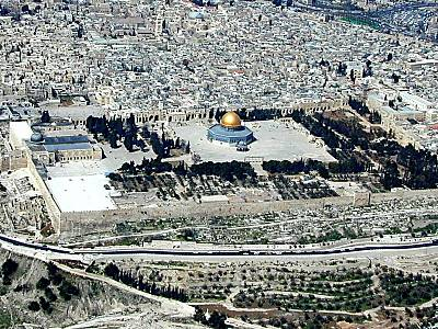
Dome of the Rock on Jerusalem's Temple Mount, facing west. |
According to Patrich, the Temple, its corresponding courtyards, chambers and
gates were oriented in a more southeasterly direction, sitting diagonally on what
is the modern Temple Mount. The difference in orientation and the placement
further eastward varies from the east-facing orientation of other scholars who
believe the Temple was closer to today's Western Wall.
However, that
difference is why, Patrich says, the Temple did not sit over the rock believed
by Jews to be the site where Abraham was prepared to sacrifice his son Isaac
and where Muslims believe Muhammad ascended into heaven.
Patrich's siting of
the Temple is derived from information collected by British engineer Sir
Charles Wilson in 1866 on behalf of the Palestine Exploration Fund. Wilson mapped a series of ancient cisterns below
the present Temple Mount platform. One of those, Patrich says, preserves a
vestige of the Temple that stood until it was destroyed by Rome in A.D. 70.
The cistern mapped by
Wilson, approximately 15 feet wide, 170 feet long and 45 feet deep, was located
near the Temple Mount's southeast corner. It was oriented in a southeasterly
direction with branches extending north and south.

|
Patrich's reconstruction of Temple in 1st century A.D., facing northeast. Courtesy Hebrew University. (Drawing by Leen Ritmeyer) |
"Until now no
one has ever thought that the location of the cistern on the Temple Mount and
its unique shape were derived from the shape and location of the altar and
sanctuary," Patrich told YNetNews.
According to the
archaeologist, this cistern is the only one found on the Temple Mount that
corresponds to descriptions in the Jewish Mishnah – the rabbinic oral
tradition compiled in the 3rd century A.D. – of daily purification and
sacrificial duties carried out by the priests on the altar in the Temple
courtyard.
The Mishnah says
water was drawn by a waterwheel mechanism from a cistern and held in a large
basin, or laver, for daily purification by the Temple's priests before they
ascended the nearby ramp to the altar to offer sacrifices.
|
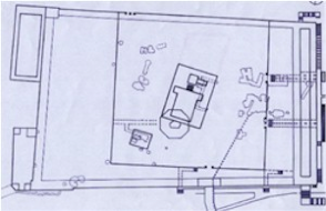
Patrich's reconstruction of Temple in 1st century A.D. overlaid on modern Temple Mount. Octagonal feature is Dome of the Rock. Diagram is oriented east up. Courtesy Hebrew University. (Drawing by Leen Ritmeyer) |
Patrich believes the
placement of the waterwheel and laver can be reconstructed from Wilson's map of
the giant southeast-trending cistern and from that, the location of the altar
and the Temple itself.
Patrich's siting has
the Temple further east and south of locations proposed by other scholars and
diagonal, rather than perpendicular to the Temple Mount's eastern and western
walls. It also leaves the rock in the Dome of the Rock outside of the confines
of the Temple itself.
Patrich said his
research on the Temple's location is strictly academic, and political
connotations should not be attributed to it.
Note Added: Professor
Joseph Patrich bases his findings on a study that was done in 1866 by the
British engineer Sir Charles Wilson for the Palestine Exploration Fund, in
which he mapped all the water cisterns in the Muslim compound (Haram
Al-Sharif), including the cistern under discussion- cistern no. 5. According to
Patrich, "Until now no one has ever thought that the location of the
cistern on the Temple Mount and its unique shape were derived from the shape
and location of the altar and sanctuary."
"We
are talking about a cistern that is 15 meters deep, with remarkable carving and
with an extraordinarily unusual shape. Its passageway is 4.5 meters wide and 54
meters long with shorter branches extending south and north," explains
Professor Patrich.
The
Mishnaic Version vs. The Babylonian Talmud
Examining
the location and the unusual shape of the cistern and studying the description
in the Mishna led Professor Patrich to the conclusion that the cistern in
question is the cistern from which water was drawn daily for the basin in the
sanctuary, during the daily ritual ceremony that occurred before dawn.
During
this ceremony, the priests officiating in the sanctuary were required to wash
their hands and feet with water from the basin, before going up to the altar.
Water from the previous day that was left in the basin overnight was invalid
for this purpose. Every day, fresh water from the cistern was required for this
ritual. According to the Mishna, a sophisticated mechanical waterwheel drew the
water. The shape of the cistern allows for the mechanism of a waterwheel.
According
to Professor Patrich, this evidence allows one to pinpoint the exact location
of the laver that the priests used in their daily ritual, and the altar ramp
that was next to it.
The exact
location of these in relation to the cistern under discussion, allows for the
first time to locate the Holy Temple itself with its gates and chambers, in
accordance with what is written in the Mishna. The conclusion from the research
places the sanctuary more east than was previously thought, and at a southern
angle, not perpendicular to the Western Wall of the Temple Mount, which was the
common opinion. This location leaves the Muslim Dome out of the confines of the
Holy Temple.
The
conclusions of this study reconcile the contradictions between the Mishnaic
text (Midot 5, 3-4) and the Babylonian text (Yoma, 19a) regarding the northern
and southern chambers. The study posits that the Mishnaic text is the correct
one, in contradiction to many commentators, first and foremost Maimonides. In
light of this, a revised plan can be drawn up of the Azarah -- the courtyard
around the sanctuary -- with its gates and chambers. Many commentators and
researchers have also deliberated this matter. (from Ynetnews February 12, 2007). For a detailed map of
cisterns under the Temple Mount see http://www.jerusalem-4thtemple.org/images/temple-maps/Haram
Underground Hydraulic System.pdf

1. Personal
Details
Prof. Joseph
Patrich
Office Address: Institute of Archaeology, Hebrew University of Jerusalem, Mt.
Scopus
Tel. #972-2-5880053 (office)
972-4-6441626 (home)
Fax
#972-2-5825548 (office)
Email: patrichj@mscc.huji.ac.il
2. Higher
Education
Hebrew University of
Jerusalem, Institute of Archaeology. Archaeology of Israel, the
Hellenistic,
Roman and Byzantine periods.
M.A. 1981 (summa cum
laude).
Ph.D. 1989 (summa
cum laude).
3. Academic Ranks
and Tenure in Institutions of Higher Education
Date-- Name of
Institution--Rank
1983-88 Hebrew
University, Jerusalem Ph.D. student Research Fellow
1984‑90 University
of Haifa, Archaeology Instructor
1990- Senior lecturer
1991- Tenure
1991-2 Dumbarton
Oaks, Byzantine Studies Research Fellow
1995 University of
Haifa, Archaeology Associate Professor
1995-6 Institute for
Advanced Studies of the Research Fellow
Hebrew University Jerusalem
1998-9 University of
Miami, Coral Gables Visiting professor
Dept. of History
Feb. 2001 École
Pratique des Hautes Études,Directeur d études invité
Section des Sciences
Religieuse,
Sorbonne, Paris
Sept. 2001-Center for
Advance Studies,Group Coordinator (together with
Feb.
2002 University of Haifa Prof. A. Raban) and Research Fellow
Oct. 2002 Hebrew
University, Jerusalem Full Professor with tenure
Institute of Archaeology
4. Offices in the
university, academic administration
1993-5 Chair of
the Department of Archaeology, University of Haifa
1995-8 Board of
Directors Member, Hecht Museum, University of Haifa
1997-98 Board of
Directors Member, Zinman Institute of Archaeology, University of Haifa.
1996-98 Member in the
M.A. Studies Committee of the Department of Archaeology, University
of
Haifa.
1995-2000 Member of
the Haifa Univ. and Yad Yizhak Ben Zvi Center Committee.
2000-2002 Member of
the Computer Committee, Faculty of Humanities, University of Haifa.
2001 Irgun_Hasegel HaBachir
Committee member, University of Haifa.
Oct. 2002- Member of the
Institute of Archaeology, Hebrew University of
Jerusalem.
2003-Chair, Computerization Committee, Faculty of
Humanities, Hebrew University of
Jerusalem
5. Scholarly
Positions and Activities Outside the University.
1983‑88 Head of archaeological survey of caves in the
Judean Desert, on behalf of the Institute of
Archaeology of the Hebrew
University.
1986‑94
Archaeological Excavations of caves in the Judean Desert (Al‑Matzaia,
caves near Kh.
Qumran, lower Wadi Makukh).
1992-95 Member of the
Editorial Board of the Journal Michmanim, Hecht Museum, University
of
Haifa.
1993-98 Co-director
of the Combined Caesarea Expedition, University of Haifa (together
with
Prof. Avner Raban, the University of Haifa, and Prof. Kenneth Holum,
the University of
Maryland, USA).
1994- 2000 Member of
the Board of Directors of the Project for Promoting Tourism to
Caesarea,
and of the Project s Committee for Planning and
Development.
1997- Member of the
Editorial Board of Yad Yizhak Ben Zvi Publishing House, Jerusalem.
1998- Member of
the Israel Council for Archaeology.
1998 Initiator and
organizer of: The Sabaite Heritage: The Sabaite Factor in the
Orthodox
Church - An international Symposium, Jerusalem and Haifa, May
24-30, 1998
1999-Member of
the Israel Exploration Society Council.
2003-Chair,
Conservation Committee, Israel Council for Archaeology.